Urban Legends

Patrick Barry, the founding member of TreeKIT’s Advisory board, has added an important new map feature — a “legend” in and of itself (pun intended).

At long last, this legend helps explain the following:

  • When zoomed out, the map displays block edges color-coded by tree density.
  • When zoomed in, individual trees become visible. Trees are classified as “Alive,” “Dead,” “Stump,” or “Empty Bed.” “Alive” trees are graded into six size classes by diameter at breast hight.
  • When closely zoomed in, individual treebed rectangles become visible.

Thank you Patrick for this great addition to the map!


Every Last One

http://www.nytimes.com/2012/07/06/nyregion/new-york-officials-increase-budget-for-care-of-street-trees.html?_r=1&hp

This NYT article, which ran on July 6th heralds good news for New York City’s street trees and the residents those trees shade.

According to the Times, the City has more than doubled its’ tree maintenance budget for the coming fiscal year. Times reporters claimed to have “revealed an uneven system of inspections and an overstretched budget for tree maintenance” in connection with reporting on a series of incidents involving lawsuits by citizens who suffered bodily harm from falling tree limbs due to negligence in tree maintenance by the City.

When TreeKIT is out in the field, the #1 issue that residents who we encounter quiz us about is City street tree maintenance. The questions range from how to get it accomplished, concern for bodily and property harm. But touchingly and most often, these residents express concern for the safety of their neighbors strolling down their block, all the while enjoying the shade and beauty that street trees in a well-maintained city can provide.

Something that these articles don’t address is what we at TreeKIT are seeing out in the field, which is that specifically trees in economically depressed neighborhoods get even less attention and maintenance than their brethren in places like Central Park and fashionable parts of town. While MillionTrees NYC has recently planted more trees on forgotten streets in many neighborhoods, the watering and pruning and treepit maintenance (so necessary for young trees newly planted) is obviously not as consistent or as complete as trees on main thoroughfares and more lively commercial areas.

Is this a function of pressure on the City from business improvement districts leaving less City maintenance money for trees on far-flung streets? Who’s lobbying for ALL of the street trees? What are your thoughts on this topic.

Report from the Field

April 28th and 29th were our first mapping outings of the season. Starting on a chilly Saturday in Astoria Queens we finishing up a few far-flung streets that were not completed last autumn. It was with a sense of satisfaction that we were able to complete the mapping of this neighborhood, one of the liveliest and most culturally diverse in the world. The range of languages spoken in this part of Queens is the highest of any neighborhood in New York City, numbering over 200 in the last Census.

As we always do when mapping, we say hello to folks whom we encounter on the sidewalks as we and our keen volunteers are taking measurements of the pits, running our measuring wheels on the curbs and then hugging the trees with tailor’s tapes to get the caliper of the trunk. Often people ask us what we are doing and take an interest or make a point of showing their children what we are up to.

One of the many aspects of TreeKIT that excite our volunteer corps and keep them coming back year after year is our focus on tree identification. Those keen to branch out beyond common names will often begin to learn the botanical Latin names of trees we map by referring to the NYCDPR Street Tree Identification sheet and it’s system of Latin name abbreviations. This always sparks a conversation about Latin roots and meanings, and what an elegant and logical system of nomenclature it continues to be.

We were thrilled to map many new trees planted in new pits and mostly with Million Trees tags. However, on several Million Trees tags we saw trees labeled with cultivar names developed by agribusinesses, and some tags had cultivar names only. A strong argument could be made to label trees with botanical Latin, especially given that Latin is certainly a more commonly understood language in such a culturally diverse neighborhood. The point of a tree-tag is to identify the tree, but when it’s a cultivar (brand) name and not a scientific name, it weakens the educational aspect of a civic tree-tagging program and smacks of corporate influence. We’d love to hear other’s thoughts on this topic.

Designing Tree Bed Guards

TreeKIT is planning a design competition for innovative guards / seating / bike parking that helps protect trees and the soil beds they grow in. Stay tuned, and in the meantime, check out the above inspirational design by Roman Vrtiska.

This design by WXY Architecture + Urban Design wraps organically around a tree while providing seating. Unfortunately the metal slats were designed to deter skateboarding.

We’re starting to save our favorite tree guards designs here: http://pinterest.com/ebarry/tree-guards/ — consider adding some pins!

Tilemill map sneak peek

We’re using Tilemill to create maps of the data mapped by TreeKIT over the past year and a half. Trees are sized according to their trunk size, red indicates a standing dead tree, orange indicates a stump, and black indicates an empty bed ready to be replanted.

All of Prospect Heights, and portions of Woodside, Sunnyside, and Astoria are complete — which neighborhood will be next?

OpenTreeMap.org features TreeKIT

Our friends at Azavea have expanded the Urban Forest Map code base into what is now known as Open Tree Map. We are delighted to be among their partners!

Check out these instances of Open Tree Map around the United States:

The original, San Francisco, created by Amber, Kelaine, Josh, Dane and many others! – http://urbanforestmap.org/

New instances created by Azavea:
Philadelphia – http://phillytreemap.org/
Sacramento – http://www.greenprintmaps.org/map/

Get in touch if you are interested in helping bring Open Tree Map to New York City.

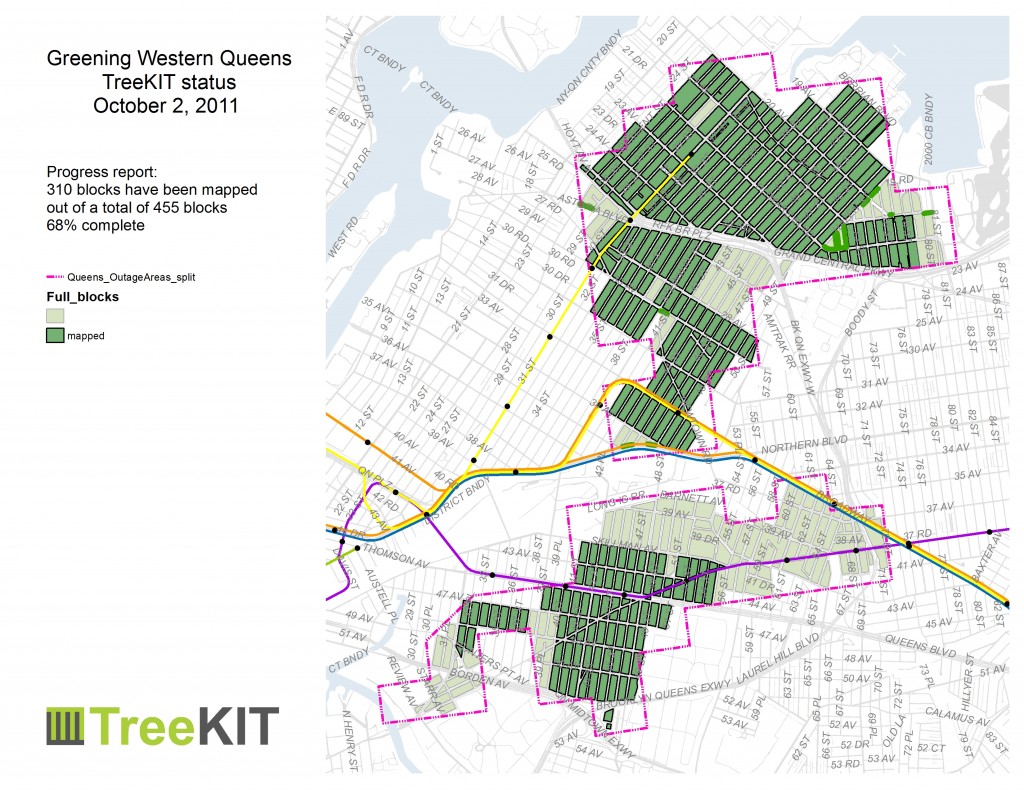
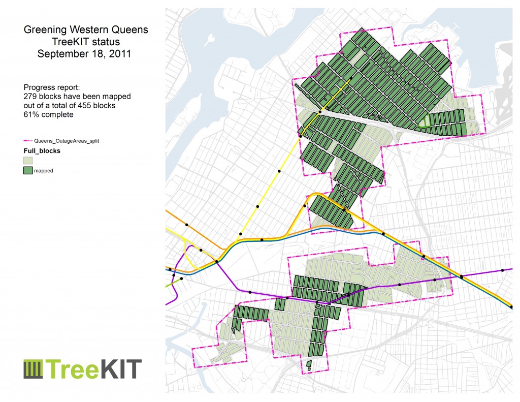
Fall 2011 update – 76% complete


Thanks to everyone who rolled blocks this summer, 76.2% of the Western Queens Outage areas have been mapped! You all made it happen!

Although we are still glad to set up parties directly with groups who want to map before the leaves drop in a few more weeks, the standing Saturday morning and afternoon sessions have come to a close for the year. Data entry continues in earnest in our new shiny postgres database courtesy of Sophia Parafina.